


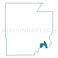
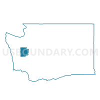
Arcadia Voting District, Mason County, Washington
About
Outline

Summary
| Unique Area Identifier | 687565 |
| Name | Arcadia Voting District |
| County | Mason County |
| State | Washington |
| Area (square miles) | 12.92 |
| Land Area (square miles) | 6.40 |
| Water Area (square miles) | 6.52 |
| % of Land Area | 49.54 |
| % of Water Area | 50.46 |
| Latitude of the Internal Point | 47.19678980 |
| Longtitude of the Internal Point | -122.93921960 |
Maps

Graphs
Select a template below for downloading or customizing gragh for Arcadia Voting District, Mason County, Washington


Neighbors
Neighoring Voting District (by Name) Neighboring Voting District on the Map
- Harstine Voting District, Mason County, WA
- Kamilche 2 Voting District, Mason County, WA
- Miller Voting District, Mason County, WA
- Pickering Voting District, Mason County, WA
- Southside Voting District, Mason County, WA
- Timberlake Voting District, Mason County, WA
- Water: Puget Sound Con 3, Thurston County, WA
- Water: Puget Sound Con 9, Thurston County, WA
- Water: Puget Sound Leg 35, Thurston County, WA
- Water: Squaxin Passage, Thurston County, WA
- Water: Totten Inlet, Thurston County, WA
Top 10 Neighboring County Subdivision (by Population) Neighboring County Subdivision on the Map
- Olympia CCD, Thurston County, WA (161,661)
- Shelton CCD, Mason County, WA (20,843)
- Olympia West CCD, Thurston County, WA (18,639)
- Timber Lake-Harstine Island CCD, Mason County, WA (7,343)
Top 10 Neighboring Unified School District (by Population) Neighboring Unified School District on the Map
- Olympia School District, WA (61,756)
- Shelton School District, WA (23,747)
- Pioneer School District, WA (10,083)
- Griffin School District, WA (5,791)
- Southside School District, WA (2,227)
Top 10 Neighboring State Legislative District Lower Chamber (by Population) Neighboring State Legislative District Lower Chamber on the Map
Top 10 Neighboring State Legislative District Upper Chamber (by Population) Neighboring State Legislative District Upper Chamber on the Map
Top 10 Neighboring 111th Congressional District (by Population) Neighboring 111th Congressional District on the Map
- Congressional District 3, WA (779,348)
- Congressional District 9, WA (723,129)
- Congressional District 6, WA (709,570)
Top 10 Neighboring Census Tract (by Population) Neighboring Census Tract on the Map
- Census Tract 120, Thurston County, WA (7,158)
- Census Tract 119, Thurston County, WA (6,767)
- Census Tract 9611, Mason County, WA (5,791)
- Census Tract 9610, Mason County, WA (4,852)
- Census Tract 121, Thurston County, WA (4,175)